*** Always remember the Flattops recreational area has a large WIDLERNESS AREA that no motorized vehicles are allowed. The North East side of the Flattops is THE FLATTOPS WILDERNESS AREA, North East of Blair Mountain. Know where the wilderness area is and do not cross the boundary. Much of the boundary is clearly separated by cliffs, but other areas are accessible, and not always marked. Regulations Link ***
Trail Map of Flattoppers Trail Map and GPS locations
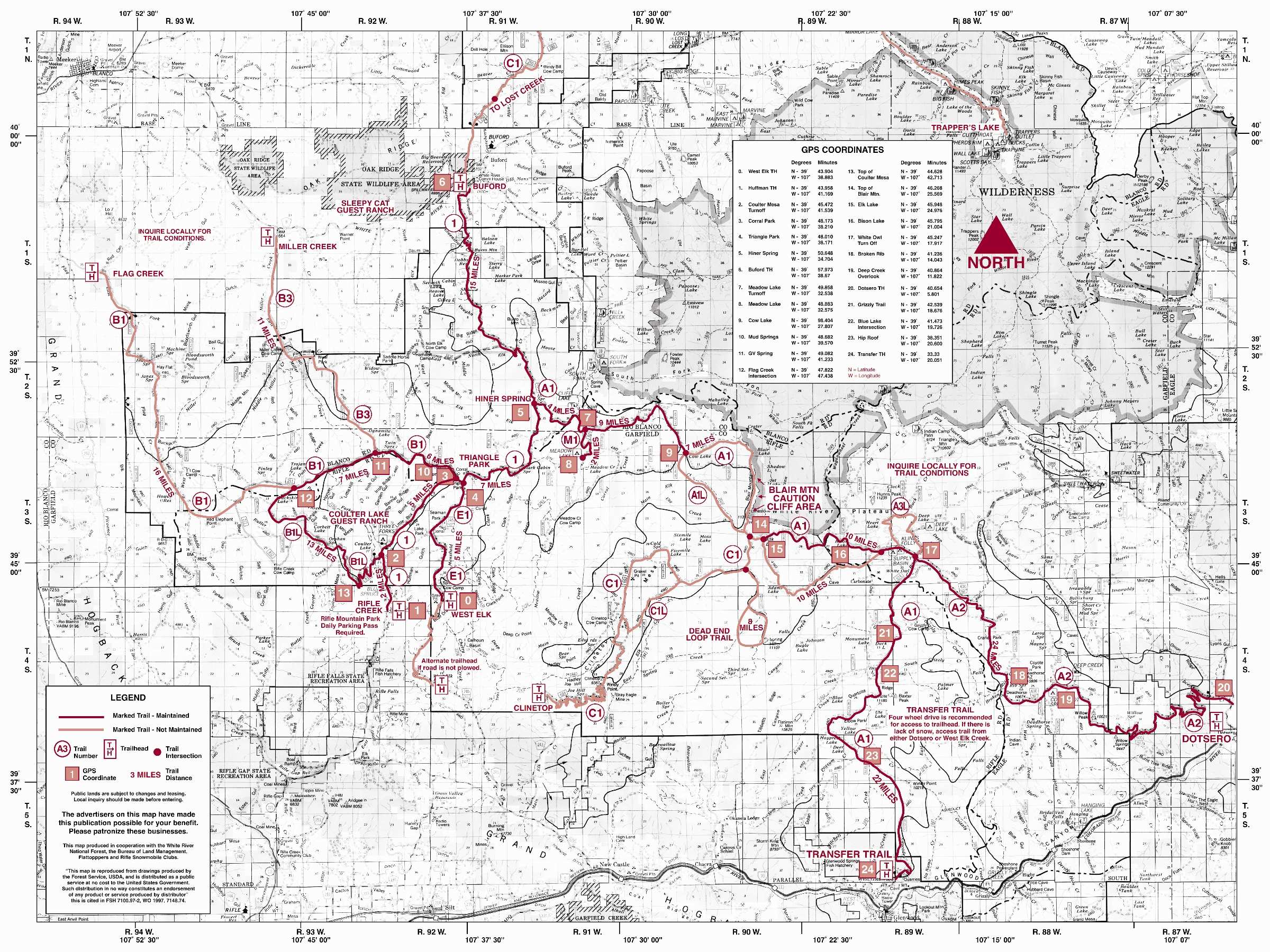
GPS Coordinates for Trail Heads and Waypoints on Flattops Trail Map
New Castle – Silt West Elk Trail Head Buford Winter Trailhead Point 0 -> 39.73192944989925, -107.64804904143519
New Castle – Silt Alternate If Not Plowed – West Elk Trail Head Buford Winter Trailhead Point 0 -> 39.68761699938999, -107.66675671378434
Rifle Huffman Gulch Rifle Creek Trail Head Point 1 -> 39.730885660281004, -107.68645737113037
Glenwood Springs Transfer Trail Trail Head Point 24 -> 39.565697196751394, -107.32371641188587
Silt New Castle – Cline Top Trail Head -> 39.67764397461436, -107.5719269232928
Dotsero Coffee Pot Road Trail Head Point 20 -> 39.67831448694259, -107.09677990199248
Meeker Buford Trail Head Point 6 -> 39.96633152549476, -107.63593142358172
Meeker – Miller Creek Trail Head -> 39.93315453958567, -107.77120108242221
Meeker – Flag Creek Trail Head -> 39.92122962922484, -107.90051795753787
Hiner Spring Buford Road Forest Road 301 to Meeker Trail Head & Meadow Lake & Triangle Park -> Destination Meeting Point 5 – 39.845402745736564, -107.57908351700465
Coulter Mesa Turnoff to Rifle Creek Trail Head – Destination Meeting Point 2 -> 39.75787981715409, -107.69232394813204
Corral Park Rifle & Meeker Trailhead Junction – Destination Meeting Point 3 -> 39.80285115395833, -107.63685018963531
Triangle Park Junction Point for Transfer Trail & Rifle & Meeker & Meadow Lake -> Destination Meeting Point 4 39.800052940063665, -107.63235282742588
Meadow Lake Turnoff Meeting Point 7 -> 39.83099853121524, -107.54230855429756
Meadow Lake Meeting Point 8 -> 39.81564614003804, -107.54195425442228
Cow Lake Junction – Destination Meeting Point 9 -> 39.816618906078936, -107.46854054782847
Mud Springs – Destination Meeting Point 10 -> 39.81180964400639, -107.66008971122781
GV Spring Twin Springs To Miller Creek Trail Head -> Destination Meeting Point 11 – 39.818128223668, -107.68728821624576
Flag Creek Intersection To Flag Creek Trail Head -> Destination Meeting Point 12 39.79741244693471, -107.75621055954277
Top of Coulter Mesa – Destination Meeting Point 13 -> 39.7419118947942, -107.72254142296445
Blair Mountain Peak Cliffs -> 39.794509076556366, -107.41729689900959
Blair Mountain Trail Top -> Destination Meeting Point 14 39.77110989876051,-107.42599157642434
Bison Lake Deep Creek Junction -> 39.76738132528955, -107.35276057064569
Elk Lake Junction – Destination Meeting Point 15 -> 39.76640287485787, -107.41284496401198
Bison Lake Trail Junction – Meeting Point 16 -> 39.75950458882491, -107.32505239818711
White Owl Turnoff Transfer Trail & Coffee Pot Junction – Meeting Point 17 -> 39.750850192562226, -107.28900408509712
Transfer Trail – Trail Gate Upper Parking – Destination Meeting Point -> 39.5685234779966, -107.31736269501633
Transfer Trail – DO NOT ENTER Private Road to Glenwood Caverns -> 39.565891415447986, -107.31806563607033
Transfer Trail Windy Point Bypass – DANGER – Always Take Left Bypass -> 39.59861830703796, -107.31436464376237
Broken Rib Creek on Coffee Pot Road – Destination Meeting Point 18 -> 39.68673799695911, -107.23370265033626
Deep Creek Trail Junction to Overlook – Meeting Point 19 – BEWARE CLIFFS -> 39.6793139820942, -107.18472135890723
Transfer Trail Top Meadows to Trees Trail Entrance – Destination Meeting Point -> 39.63753112401905, -107.33812885641512
Grizzly Trail Intersection Trail Junction off Transfer Trail – Meeting Point 21 -> 39.71009242987912, -107.31103901646064
Blue Lake Intersection Trail Junction off Transfer Trail – Meeting Point 22 -> 39.69327381588481, -107.32813167234383
Hip Roof Junction off Transfer Trail – Meeting Point 23 -> 39.63928338339897, -107.34393508542684
Map of Flattoppers Grooming Area
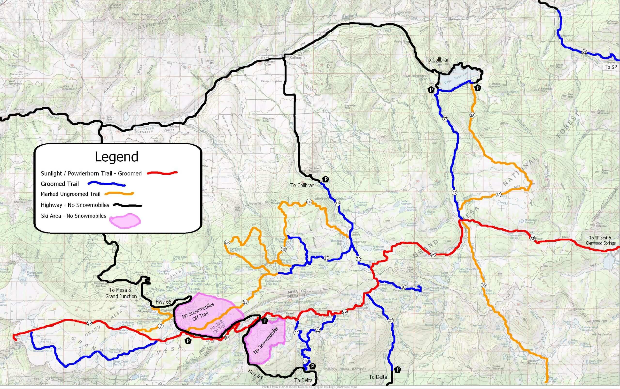
Grand Mesa Snowmobile Trail Map
Grand Mesa Forest Service Trail Map
Grand Mesa Sunlight - Powderhorn EAST MAP Glenwood Springs Side
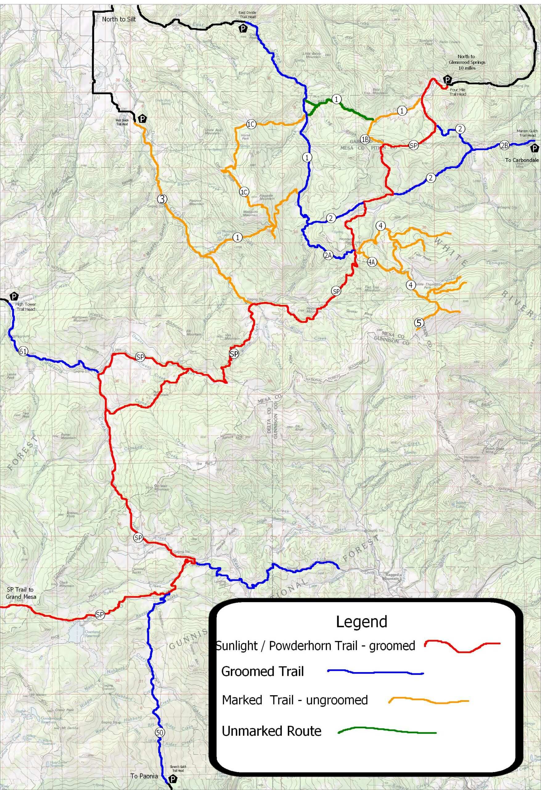
Grand Mesa Sunlight - Powderhorn WEST MAP Powderhorn Side